Quick answer
Choose the source route that fits your trip: a 2-day self-drive, a 4-day cycling loop, or a 6-day walking/transfer outline. The original day counts are preserved; Bird Island and Sand Island are closed protected areas, so do not enter them.
- 2 days by car: Xining → Riyue Mountain → Erlangjian / 151 Base → Chaka Salt Lake → Heimahe, then return via a currently authorized lake-viewing stop, Jinyintan, and Atomic City.
- 4 days by bicycle: Xining → Xihai Town → east and south shore → Heimahe → west/north shore → Gangcha → Xihai Town → Xining.
- 6 days on the source’s walking/transfer outline: its first day explicitly includes vehicle transfers; the historic Bird Island and overnight details need current legal-access and lodging checks.
- Lake-loop road upgrades were reported underway in August 2026; verify live roadworks, weather, and visitor notices before departure.
- Self-drive plan
- 2 days · source day count retained
- Cycling plan
- 4 days · source day count retained
- Walking / transfer plan
- 6 days · source day count retained
- Food photo
- Qinghai-style yogurt · supplied PDF
- Publication
- PDF route outline · verify current details
How many days to spend
The PDF has three separate trip formats. This guide keeps all their original day counts rather than reducing them to one generic itinerary.
- 2 days: The complete self-drive outline in the supplied PDF, with a long first day and current-access substitutions on day two.
- 4 days: The full lake-loop cycling outline from the PDF; check current roadworks, wind, services, and legal access before riding.
- 6 days: The source’s full walking/transfer outline. It includes vehicle transfers and historical stops, so verify route feasibility and every overnight locally.
Where to stay
Xining
Best for: Arrival, departure, and the source routes’ city base
The PDF routes begin or end in Xining. Choose current accommodation to match your confirmed transport; no old property, address, phone number, or rate is reused.
A currently operating open-route settlement around the lake
Best for: Breaking up a multi-day lake-loop trip
Compare current map access with the open route and confirmed transport. The PDF’s named hotels and tent accommodation are dated and are not recommendations or booking leads.
Best time to visit
- The old PDF’s season-specific predictions are not reused as current advice. Check the forecast, wind, road notices, visitor-area status, and any local alerts for your exact dates.
- The source includes birding and rapeseed-flower scenery, but timing varies by year and location; do not treat a fixed date or bloom prediction as guaranteed.
Getting around
The PDF contains car, bicycle, and walking/transfer outlines. The lake-loop road network is being upgraded and current visitor access differs from the older guide; verify open roads and approved viewing sites close to departure.
- Bird Island and Sand Island are long-term closed ecological-sensitive zones; do not enter. Use only public viewing areas confirmed open by current notices.
- A road-quality project across lake-loop routes was reported underway in August 2026. Check construction, traffic controls, and any detours before driving or cycling.
- The source’s transit times, bus details, fares, distances, and service listings are historic and omitted.
- The six-day source walking plan starts with vehicle transfers. It is not a continuous verified hiking trail or turn-by-turn route.
Arriving in Qinghai Lake
This guide does not reuse historic airport, transfer, or schedule details from the supplied PDF.
Confirm the arrival station and onward route using your current ticket and a live map.
Transport notes
Recheck lake-loop road conditions
The provincial report says a multi-road lake-loop quality-upgrade project was underway in August 2026. Check current official traffic and construction notices before fixing a driving or cycling schedule.
Keep protected areas out of the route
Bird Island and Sand Island are closed ecological-sensitive areas. Do not navigate into either reserve; use only an officially open public viewing point confirmed for the date of travel.
A practical 2-day outline
This is the city-level sequence. Open the day-by-day itinerary for detailed stops, timing, meals, transfers and backup options.
Day 1 · Xining · Riyue Mountain · Qinghai Lake south shore
Xining → Riyue Mountain → Erlangjian → Chaka Salt Lake → Heimahe
Keep the PDF’s first day in order: depart Xining, pass Riyue Mountain and the Erlangjian (151 Base) area, continue to Chaka Salt Lake, then overnight around Heimahe. The source says this is a long day and assumes an early start; check current road and site conditions before deciding whether to include every stop.
Day 2 · Qinghai Lake north shore · Haibei · Xining
Heimahe → approved lake-viewing stop → Jinyintan → Atomic City → Xining
The PDF’s second day returns from Heimahe via the Bird Island area, Jinyintan Grassland, and Atomic City. Bird Island itself is long-term closed; replace that historical stop with an observation area currently authorized for visitors, such as Xianwan only if local notices confirm access.
Places and details in photos

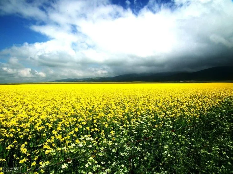
Rapeseed fields beside Qinghai Lake

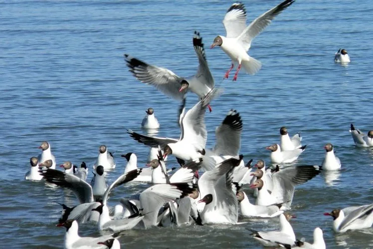
Birds over the lake

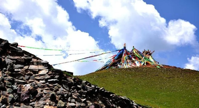
Prayer flags on the open plateau

Qinghai-style yogurt
Booking and access checks
Confirm open areas and current overnight options
The older PDF’s scenic-area, accommodation, and booking details are not current. Confirm visitor access, lodging, roads, and return transport through current local/official information before setting out.
Complete two-day self-drive route from the PDF
Both source days are retained. Day one is a long route; current access, road works, weather, and opening information may require you to skip or reorder stops. The Bird Island visit printed for day two is replaced by a current, authorized public viewing point.
- Day 1
Xining → Riyue Mountain → Erlangjian → Chaka Salt Lake → Heimahe · 西宁 → 日月山 → 二郎剑景区(151基地一带) → 茶卡盐湖(按当日时间与开放情况取舍) → 黑马河周边住宿(当前可订地点需另行确认)
Keep the PDF’s first day in order: depart Xining, pass Riyue Mountain and the Erlangjian (151 Base) area, continue to Chaka Salt Lake, then overnight around Heimahe. The source says this is a long day and assumes an early start; check current road and site conditions before deciding whether to include every stop.
- Day 2
Heimahe → approved lake-viewing stop → Jinyintan → Atomic City → Xining · 黑马河 → 当前获准开放的湖区观景点(不进入鸟岛;以现场公告为准) → 金银滩草原 → 原子城 → 西宁
The PDF’s second day returns from Heimahe via the Bird Island area, Jinyintan Grassland, and Atomic City. Bird Island itself is long-term closed; replace that historical stop with an observation area currently authorized for visitors, such as Xianwan only if local notices confirm access.
Complete four-day lake-loop cycling route from the PDF
The four-day cycling structure is reproduced without compressing the route. Road surfaces, legal riding access, construction, lodging, wind, and weather need fresh local checks; the Bird Island scenic zone is not an accessible stop.
- Day 1
Xining → Xihai Town → East Lake Loop Road → G109 → Erlangjian · 西宁 → 西海镇 → 环湖东路 → G109国道 → 二郎剑(151基地一带)
Day 1 follows the PDF’s cycling sequence from Xining to Xihai Town, then along the east lake loop road and G109 toward the 151 Base area.
- Day 2
Erlangjian → Heimahe · 二郎剑(151基地一带) → 黑马河
Day 2 keeps the source’s south-shore leg from Erlangjian to Heimahe.
- Day 3
Heimahe → Shinahe → Bird Island area → Gangcha · 黑马河 → 石乃亥 → 鸟岛周边公共道路(不进入鸟岛保护区) → 刚察县
Day 3 follows the west/north shore toward Gangcha. The PDF names Bird Island, but the protected scenic area is closed; ride only on currently permitted public roads and use an officially open viewing point if one is confirmed.
- Day 4
Gangcha → Xihai Town → Xining · 刚察县 → 西海镇 → 西宁
Day 4 retains the PDF’s finish through Xihai Town and back to Xining.
Complete six-day walking and transfer outline from the PDF
All six source days are kept. The PDF itself includes vehicle transfers, historical lodging references, and a Bird Island visit; this is a historical route outline, not a validated walking track. Use only current public roads and authorized viewpoints, and independently confirm every overnight stop.
- Day 1
Xining → Riyue Mountain Pass → Heimahe · 西宁(乘车) → 日月山口 → 黑马河(乘车接驳)
The PDF labels this a six-day lake-loop walking plan, but its first day explicitly includes vehicle transfers from Xining to Riyue Mountain and onward to Heimahe. Preserve that source structure while treating the day as a transfer-and-walk outline.
- Day 2
Heimahe → Buha River → Bird Island town area · 黑马河 → 布哈河一带 → 鸟岛镇周边(仅限当前获准道路)
Day 2 keeps the PDF’s route grouping toward Buha River and the Bird Island town area. Bird Island reserve access is closed; stay on currently permitted public routes and do not enter the reserve.
- Day 3
Bird Island area → approved viewpoint → historic overnight area · 鸟岛周边(不进入保护区) → 当前获准开放的替代观景点(以现场公告为准) → 原文帐房宾馆一带(旧住宿信息,须重新核实)
The source routes this day through Bird Island to a named tent hotel. Keep the day in the six-day frame, but replace entry to the closed reserve with a currently approved public viewpoint and treat the old lodging name as a historical locator only.
- Day 4
Historic overnight area → Beixiangyang Ancient City → Quanji · 原文帐房宾馆一带(住宿需核实) → 北向阳古城 → 泉吉
Day 4 preserves the source’s sequence from its old tent-hotel area via Beixiangyang Ancient City to Quanji.
- Day 5
Quanji → Gahai Ancient City → Atomic City → Xihai Town · 泉吉 → 尕海古城 → 原子城 → 西海镇
Day 5 follows the PDF’s north-shore sequence through Gahai Ancient City and Atomic City to Xihai Town.
- Day 6
Xihai Town → Hudong Sheep Farm → Riyue Mountain → Daotang River · 西海镇 → 湖东种羊场 → 日月山 → 倒淌河
Day 6 retains the PDF’s finish from Xihai Town via Hudong Sheep Farm and Riyue Mountain to Daotang River.
Qinghai food notes from the PDF
The source food section highlights regional dishes rather than verified current venues. The yogurt card uses the clean, text-free food photograph in the supplied PDF. Ask locally about ingredients, availability, and preparation; no old restaurant listings or prices are reused.
Qinghai-style sour yogurt · 青海酸奶
The supplied guide includes a clear photograph of a bowl of local yogurt. Styles and availability vary; check ingredients and preparation locally.
Hand-grabbed lamb · 手抓羊肉
A regional dish listed in the PDF. This is a food idea, not a recommendation for a named restaurant or a claim about present-day availability.
Niangpi and ga mianpian · 酿皮 · 尕面片
The guide mentions these local wheat-based foods. Serving styles and availability vary by place; ask about ingredients if needed.
Offal soup and lamb-intestine noodles · 杂碎汤 · 羊肠面
Regional soup and noodle dishes noted in the source. Ask about ingredients and preparation, especially if you have dietary restrictions.
Menyuan milk skin · 门源奶皮
A dairy specialty listed by the PDF. The guide does not assert a current vendor, address, or price.
Local planning tips
- Bird Island and Sand Island are closed ecological-sensitive areas; do not enter them. Use only a public viewing area that current local notices confirm is open.
- As checked on 2026-09-26, a lake-loop road quality-upgrade project had begun and is expected to span multiple roads. Recheck current construction, traffic-control, and weather notices before cycling or driving.
- Qinghai Lake is a high-altitude destination. The CDC Yellow Book recommends planning for altitude exposure and ascent; consult a qualified health professional before travel if you have relevant health concerns, and seek current local help if unwell.
- The PDF’s old fares, opening hours, schedules, telephone numbers, hotel listings, and exact trip estimates are not current travel instructions and are omitted.
- If cycling or walking, decide on a conservative fallback and return plan before setting off; exposed roads, wind, weather, and services can change the day’s feasibility.
Common planning mistakes to avoid
- Do not enter Bird Island or Sand Island; use only visitor areas confirmed open by current notices.
- Do not rely on the PDF’s old schedules, fares, property names, phone numbers, distances, opening hours, or road conditions.
- Do not treat the six-day route as a continuous verified walking trail; the original includes vehicle transfers.
- Do not assume Chaka Salt Lake, a flower-viewing area, or a lakeside viewpoint is open on your date; verify access and allow for road works.
How to make the route work
Choose a route by travel mode, not by a single fixed duration
The PDF separates the compact car loop, a four-day cycle loop, and a six-day walking/transfer outline. Keeping them separate makes their different effort and logistics visible without altering the source’s day counts.
Use a permitted viewpoint instead of a closed ecological reserve
Bird Island is prominent in the older route notes but is not an open sightseeing stop. Current official/local information takes precedence; the route modules redirect visitors to a currently authorized public viewing point only if it is confirmed open.
Frequently asked questions
How many days does the Qinghai Lake PDF recommend?
It gives three different plans: 2 days by car, 4 days by bicycle, and 6 days for a walking/transfer loop. This page preserves each duration separately.
Can I visit Bird Island or Sand Island?
No entry is recommended here: current reports describe both as long-term closed ecological-sensitive areas. Check current local notices and choose only an authorized public viewing area.
Is the six-day plan a full hiking trail?
No. The PDF itself says its first day includes vehicle transfers, and it does not provide a validated current track. Confirm legal routes, transfers, and overnight stops locally.
Are the PDF’s transport and lodging details still current?
They are from an older edition and are omitted as current advice. Verify road construction, access, transport, and accommodation close to travel.